Contributing to flood control measures in Tunisia through data analysis with DIAS
"Majrda testour" CC BY-SA 3.0 via wikimedia commons
Objective
The Republic of Tunisia is located in the north of the African continent. While it has long suffered from water shortages, torrential rains have frequently occurred in recent years. The severe flooding of the Medjerda River that occurred in January 2003 resulted in the death of 10 and the displacement of 27,000 people. Furthermore, the flooding continued for over a month, leading to enormous social and economic damage as a result of the damage to crops and buildings, transportation outages, and the like. This kind of large-scale flooding is becoming a risk factor in the achievement of sustainable development.
Accordingly, the University of Tokyo was commissioned by JICA to conduct a “Survey on Integrated Watershed Management and Flood Measures in Consideration of the Impact of Climate Change” in 2012. Aiming to analyze flood runoff in the Medjerda river-basin and evaluate the impact of future climate change on rainfall and flood patterns, the survey utilized DIAS at various stages of the investigation.
Data analysis
First, long-term observation rainfall data, temperatures, and river flow rates were obtained for the Medjerda river-basin for the period January 1950 to December 2007. The data was inserted into the infrastructure system after having undergone formatting and quality management. Second, Digital Elevation Models (DEM), topography, soil, and land use characteristics data archived in DIAS were used with satellite observation data to virtually reproduce the characteristics of the Medjerda river-basin. Third, support was given for the construction of a model to calculate the flow of water. Fourth, it was made possible to input CMIP3 data archived in DIAS into the model.
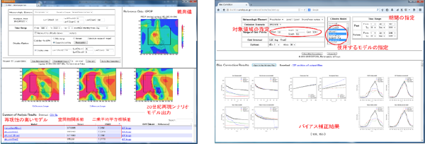
However, this data comprised multiple data sets with inconsistent output elements, intervals, calendars, units, and other items, necessitating the development of an application that enables the quick selection and error correction of data by simple input and mouse operation. Accordingly, an application for the integrated analysis of these data was developed on a high-capacity disc space to realize a system on which high-speed, accurate, and advanced analysis could be carried out effectively.

Figure 1: An analysis tool for removing models from within the 18 model outputs of CMIP3 that do not express the characteristics of the subject area (left), and a tool for correcting the bias in rainfall and analyzing future rainfall patterns (right)

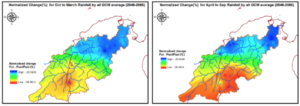
Figure 2: The change in the spatial distribution of seasonal rainfall during the rainy season (left) and the dry season (right) in future (2046-2065):
Seasonal rainfall tends to decrease in both the rainy season and the dry season across the region. The greatest decrease was shown to occur at the upper reaches of the basin during the dry season.
Results
By performing rainfall data analysis and flow rate analysis for the past 57 years, the rainfalls and water levels (probable precipitation, basic flood level, and probable flood discharge) were established for use in a river improvement plan for the Medjerda river-basin. In addition, the tendency for water shortages to be produced in the Medjerda river-basin was clearly demonstrated by evaluating the impact of future climate change. Meanwhile, the tendencies for torrential rains and floods to both increase and decrease were observed according to the data set, indicating the strong influence of CMIP3 data uncertainty.
Furthermore, effective methods to accommodate both drought prevention measures and flood control measures were demonstrated by constructing and analyzing an optimum operation model for dams taking into account the flow time of floods. These investigation and analysis results from DIAS were highly evaluated, and the loan agreement for the Medjerda River Flood Control Project was signed between JICA and Tunisia on July 17, 2014. As such, the results of DIAS have made a significant contribution to international aid.

